|
 Since
early times, Almeida’s strategic
position has served as a
backdrop for the population, as it
negotiates the vicissitudes of
history. The terrain within the
municipality, or Concejo, is
defined by the slopes formed by
the River Côa.
Since
early times, Almeida’s strategic
position has served as a
backdrop for the population, as it
negotiates the vicissitudes of
history. The terrain within the
municipality, or Concejo, is
defined by the slopes formed by
the River Côa.
 |
Traces of human occupation
are lost in the mists of pre-history.
Nonetheless, the greatest
vestiges of settlement
reflect a circumstance of
the utmost importance: the
town’s strategic
location. There is an
inevitable need to address
the historical roots of
the name
"Almeida", which
has Muslim influences.
For some historians, the
word stems from the Arabic
"al meda"
or "talameyda",
which means "table",
in clear reference to its
flat terrain. For others,
the name comes from "atmeidan"
which means "field"
or "place where
horses are galloped",
a common activity amongst
the Arab peoples.
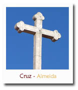
Almeida
has long been marked by a
history of territorial
consolidation. It has always
been a focal point for
contesting land rights, yet
it first became the scene of
major historical events
during the Christian
Reconquest |
|
of
the Iberian Peninsula. The
area was taken from
the Muslims by King
Dinis en 1296,
including the lands on the
right bank of the River
Côa.
The
town’s boundaries were
defined by the Treaty
of Alcañices, which
Don Manuel established
"in foro"
in 1510.
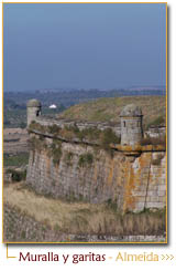
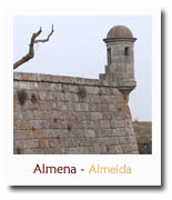
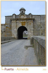
The
town of Almeida is
surrounded by ramparts
and pointed bastions
that form a hexagonal star
shape. |
|
|
|
 |
|